The county road on Lake Nona's west and south sides that feeds the airport's south entrance, SR 417 and, at its far north end, SR 528.
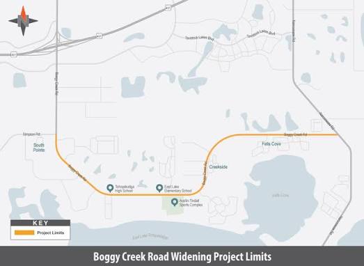
Boggy Creek Road runs north–south along the western side of Lake Nona, then turns east at Simpson Road and follows Lake Nona's southern edge to Narcoossee Road. Its north end meets SR 528, and it crosses SR 417 at Exit 17B, where flyovers opened in 2016 also connect the toll road to Jeff Fuqua Boulevard and Orlando International Airport's south entrance. A ramp from Boggy Creek Road onto Jeff Fuqua Boulevard reaches the terminals, including Terminal C, without using SR 417. Orange County finished widening its stretch to four lanes, from the county line to Lake Nona Boulevard, in October 2023. Osceola County's four-lane widening between Simpson Road and Narcoossee Road is scheduled to finish at the end of 2026.
Most descriptions of Lake Nona are built around Narcoossee Road on the east and SR 417 on the north. Boggy Creek Road is the side of the frame that gets less attention, and it is the side that matters most if you fly often. It starts at the Beachline, runs down past the airport's south entrance, crosses SR 417, meets Lake Nona Boulevard, and then bends east along the bottom of the community to Narcoossee Road.
It is easy to picture it wrapping Lake Nona's south and east. It actually covers the west and the south. Narcoossee Road is the east side, and the two roads meet at the corner where Summerdale Park sits. That difference decides which neighborhoods get the short trip to the airport, and which ones sit next to the construction.
Where does Boggy Creek Road run?
Boggy Creek Road runs north–south from SR 528 to the Orange–Osceola county line along Lake Nona's western side, then turns east at Simpson Road and follows Lake Nona's southern edge to Narcoossee Road.
At its north end, Boggy Creek Road meets SR 528 near Jetport Drive and continues west as McCoy Road. Heading south, it passes the Airport International Park business district at Tradeport Drive, runs alongside Jeff Fuqua Boulevard, and passes under SR 417 at a diamond interchange. South of the toll road, J Lawson Boulevard branches west to the Beacon Park development, and Lake Nona Boulevard branches east toward Medical City. The Publix-anchored Lake Nona Creekside center sits on the northwest corner of that intersection, which is a reminder that the road is Lake Nona's working western edge rather than a hard boundary: a few Lake Nona properties sit on its far side.
The name catches people out at the county line. There, Simpson Road continues southwest toward Osceola Parkway and Kissimmee, while Boggy Creek Road turns east as Osceola County's CR 530. A driver who stays straight to "stay on Boggy Creek" ends up on Simpson Road. The eastern stretch runs about 5.9 miles to Narcoossee Road, finishing just south of Summerdale Park. For how this fits the rest of the map, see where Lake Nona sits.
| Jurisdiction | Orange County from SR 528 to Simpson Road; Osceola County (CR 530) from Simpson Road east to Narcoossee Road |
|---|---|
| North end | SR 528 (Beachline Expressway) near Jetport Drive, continuing west as McCoy Road |
| Expressway connections | SR 528 at the north end; SR 417 at Exit 17B |
| Airport connection | Ramps to Jeff Fuqua Boulevard at the SR 417 interchange, leading to the south entrance and Terminal C |
| Lake Nona intersections | Lake Nona Boulevard on the west side; Narcoossee Road at the southeast corner |
| Lanes | Four lanes from Lake Nona Boulevard to the county line since October 2023; the Osceola stretch is being widened to four lanes |
| Tolls | None on Boggy Creek Road itself |
How does Boggy Creek Road connect Lake Nona to Orlando International Airport?
Boggy Creek Road feeds the airport's south entrance: at the SR 417 interchange, a ramp connects it to Jeff Fuqua Boulevard, the airport expressway that runs north to the terminals, including Terminal C.
Jeff Fuqua Boulevard is the main road into Orlando International Airport. Its southern leg runs over the top of Boggy Creek Road beside Boggy Creek Swamp and ties into the SR 417 interchange. Coming from Lake Nona Boulevard, you can drive north on Boggy Creek Road and take the entrance ramp onto Jeff Fuqua Boulevard without ever getting on SR 417. That is the route to know if you would rather not pay a toll to reach the airport.
The south entrance matters more than it did a few years ago. Terminal C opened on September 20, 2022, with an address on Jeff Fuqua Boulevard South, and the Brightline station beside it began intercity rail service in 2023. Both sit at the end of the road Lake Nona's west side is closest to. Leaving the airport, follow the signs for the South Exit; the exit for Boggy Creek Road comes just before the ramps to SR 417. Take it if you are heading to the west side of Lake Nona by surface road, or stay left for SR 417 if you are heading east. For drive times from different parts of the community, see our Lake Nona commuting guide.
How does the SR 417 interchange at Boggy Creek Road work?
It is two exits in one system: Exit 17A is a flyover to Jeff Fuqua Boulevard and the airport, and Exit 17B is a diamond interchange with Boggy Creek Road itself.
The Central Florida Expressway Authority rebuilt the interchange in a $71 million project that began in October 2013 and was completed on February 12, 2016. It added three high-speed flyovers linking SR 417 to Jeff Fuqua Boulevard, above the ramps that serve Boggy Creek Road. Before that, airport traffic and local traffic shared the same ramps. The separation is why Boggy Creek Road works as a local street now rather than as the airport's front door.
The toll road itself has grown too. A widening completed in fall 2024 took SR 417 to six lanes from Landstar Boulevard to Exit 17B. Heading east on SR 417 from the interchange, the next exit is Lake Nona Boulevard at Exit 19. For a Lake Nona household the practical choice is between the two: Boggy Creek Road for the west side, or SR 417 to Exit 19 for Medical City and points east. Our guide to SR 417 and SR 528 covers the toll road side in more detail.
Which parts of Lake Nona does Boggy Creek Road serve?
It serves Lake Nona's west side through the Lake Nona Boulevard intersection, and its southern edge through the stretch near Narcoossee Road, where Summerdale Park has its entrance.
Lake Nona Boulevard runs east from Boggy Creek Road into Medical City, so for the hospitals, the UCF College of Medicine and the research campuses, Boggy Creek Road is the western approach. Tavistock lists Somerset Park and Laureate Park among the neighborhoods its Lake Nona Creekside center was built to serve, which tells you where the road's local traffic comes from.
On the southern edge, Summerdale Park's roughly 208 homes sit on the north side of Boggy Creek Road just west of Narcoossee Road, with Isles of Lake Nona directly north and Fell's Landing next door. Lake Nona's development plans include Centerline Drive, a north–south road planned to run from Kellogg Avenue to Luminary Boulevard and continue south to Boggy Creek Road, which would give the south side a second way north into the community. Farther east, Moss Park Road and the Eagle Creek corridor handle the southeast.
What road work is happening on Boggy Creek Road?
Orange County's section is finished and Osceola County's is not: Orange widened its stretch to four lanes in October 2023, and Osceola's $89.8 million widening from Simpson Road to Narcoossee Road is scheduled to finish at the end of 2026.
Orange County turned its section, from the county line north to Lake Nona Boulevard, from a two-lane rural road into a four-lane divided road with sidewalks, bike lanes and lighting. The $9.4 million project opened for use in October 2023, about 300 days ahead of schedule. The county described Boggy Creek Road as a vital route for Medical City employees, residents, and people commuting from SR 417 south into Osceola County.
Osceola County's project is larger and slower. Work on the 5.9-mile stretch began in November 2023 and adds a lane in each direction, an 8- to 10-foot multi-use path on the south side, a 6- to 8-foot sidewalk on the north side, and signal changes at Nele Road, Turnberry Boulevard and Narcoossee Road. In December 2025 the county put the project at about 60 percent complete, with two-way traffic running on the new westbound lanes in a temporary layout. In June 2026 crews shifted the Narcoossee Road intersection into a split configuration while they worked in the median. Residents have pushed for a signal at Pearson Avenue and Grouse Avenue, which is not in the current plans.
| Project | Status |
|---|---|
| Orange County: county line to Lake Nona Boulevard, two lanes to four | Opened October 2023; $9.4 million |
| Osceola County: Simpson Road to Narcoossee Road, about 5.9 miles, two lanes to four | Under construction since November 2023; $89.8 million; scheduled for the end of 2026 |
What will SR 534 change for Boggy Creek Road?
SR 534 is a planned 14-mile toll expressway that will start at SR 417 near Boggy Creek Road and run east through northeast Osceola County, giving the traffic that now crowds Boggy Creek Road and Narcoossee Road a parallel route.
The Central Florida Expressway Authority lists relief for Boggy Creek Road, Narcoossee Road and Cyrils Drive, and better access to the airport, among the project's goals. Its current schedule has construction of the 8.4-mile section between SR 417 and Cyrils Drive beginning in 2027, a partial opening in 2030, and all 14 miles complete by 2032. The first phase runs north of Boggy Creek Road, behind the Spring Lake Village and Turnberry Reserve subdivisions in Osceola County.
Two things to keep in mind. The project has drawn opposition because the corridor passes through Split Oak Forest, one of the protected natural areas closest to Lake Nona. And its west end ties into SR 417 at the same interchange that serves Boggy Creek Road, so the area around Exit 17B should expect construction of its own once work begins. Boggy Creek Road stays free; SR 534 will be tolled.
Is living near Boggy Creek Road a plus or a minus?
For a household that flies often or commutes toward Kissimmee, it is a plus; for a home that backs onto it, the traffic and the construction through 2026 and beyond are real costs.
Pros
- A surface-road route to the airport's south entrance and Terminal C that does not require SR 417.
- Direct SR 417 access at Exit 17B, plus SR 528 at the road's north end, so both expressways are reachable from one road.
- Four lanes from Lake Nona Boulevard to the county line since October 2023, with sidewalks and bike lanes.
- Groceries and fuel at Lake Nona Creekside, on the corner of Lake Nona Boulevard.
Cons
- The Osceola stretch has been a work zone since November 2023 and is scheduled to stay one until the end of 2026, with shifting lane layouts along the way.
- Much of its traffic is not Lake Nona's. Orange County itself describes the road as a route for commuters between SR 417 and Osceola County, and that traffic stays after the widening is done.
- SR 534 construction is expected to begin in 2027, with its west end at the same SR 417 interchange.
- The turn at Simpson Road confuses visitors and delivery drivers, who follow the straight road and end up on Simpson Road.
Our Take
Boggy Creek Road is the strongest argument for Lake Nona's west side, and most buyers never look at it because they are looking at SR 417. If airport access is on your list, check how a neighborhood reaches Boggy Creek Road, not only how it reaches the toll road. If quiet is on your list, check whether the lot backs onto it. And if you are buying on the south edge near Narcoossee Road, the next several years at that corner include a finished widening and a new toll road being built to the north. That is a trade, not a dealbreaker, but price it in rather than finding out at the first closing-day traffic jam.
What do Lake Nona neighbors know about Boggy Creek Road?
Neighbors treat Boggy Creek Road as the back door to the airport and the Publix, and they plan around the construction at the county line rather than through it.
The practical habits are simple. Heading to the airport from the west side, stay on Boggy Creek Road and take the Jeff Fuqua ramp rather than looping onto SR 417. Coming home, take the Boggy Creek Road exit before the SR 417 ramps. Heading south toward Kissimmee, remember that Boggy Creek Road turns east at the county line and Simpson Road is the one that keeps going. And until Osceola County's lanes are finished, allow for the work zone east of Simpson Road.
None of this shows up on a listing. It is the kind of thing that decides whether a house works for how you actually live, which is why the road belongs in the conversation alongside schools and HOA fees. For the full picture of how Lake Nona connects to the rest of Orlando, start at our Lake Nona roads and transportation hub.
Where can I check official updates on Boggy Creek Road?
Orange County, Osceola County and the Central Florida Expressway Authority each publish updates for their own sections.
- Orange County: Boggy Creek Road South project
- Orange County newsroom: widening completed
- Osceola County: Boggy Creek Road project
- Central Florida Expressway Authority: SR 534
- Orlando International Airport
Weighing a Lake Nona home against its commute? Call/Text David Myers at 407.801.3286 or use the contact form.
Frequently asked questions about Boggy Creek Road
Where does Boggy Creek Road start and end?
Can I reach Orlando International Airport from Lake Nona without using a toll road?
What exit is Boggy Creek Road on SR 417?
When will the Boggy Creek Road widening be finished?
What is SR 534 and how does it relate to Boggy Creek Road?
Which Lake Nona neighborhoods are closest to Boggy Creek Road?