What the "40 miles of trails" figure really measures, where to start, and the gaps to know about before you ride
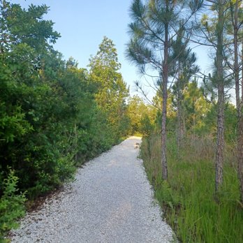
Lake Nona's trail network is anchored by the Orlando Southeast Trail, a City of Orlando system of multi-use paths about 13 miles long and 12 feet wide. About 90 percent of the Orlando Southeast Trail is off-street, and its designated trailhead is Heroes Community Park at 14028 Centerline Dr. Lake Nona's developer markets more than 40 miles of paved and unpaved trails and paths, a figure that includes neighborhood connector paths as well as the main trail. About 40 percent of Lake Nona is reserved as open green space. The Moss Park Road leg ends about a mile short of Moss Park, so riders heading to the park use an on-road stretch for the last segment.
Builder brochures in Lake Nona often quote "over 40 miles of trails." It's a fair number, but it counts every neighborhood path and wide sidewalk as well as the main trail. Worth knowing before you buy a bike, or a house, expecting 40 uninterrupted miles.
Here's what the network really is, where to start, how the legs connect, and the gaps that haven't been closed yet.
How many miles of trails does Lake Nona have?
Lake Nona's developer markets more than 40 miles of paved and unpaved trails and paths; the main continuous route, the Orlando Southeast Trail, is about 13 miles.
Some local guides round the total to 44 miles. Either way, the figure measures how walkable the whole community is, not the length of one continuous route. It includes neighborhood connector paths and wide sidewalks alongside the main trail. About 40 percent of Lake Nona is reserved as open green space, which is why so much of the network runs past water and conservation land.
What is the Orlando Southeast Trail?
The Orlando Southeast Trail is a City of Orlando network of multi-use paths through Lake Nona, about 13 miles long, 12 feet wide and about 90 percent off-street.
The paths are asphalt and concrete, shared by walkers, runners, cyclists and strollers. According to the city, the trail passes through East Park, Education Village, Lake Nona Central, Lake Nona Estates, Lake Nona South, La Vina, Northlake Park and Randal Park. It isn't one loop: it's a spine along Lake Nona Boulevard with branches off Narcoossee Road and Moss Park Road.
Where do you start on the Lake Nona trails?
Start at Heroes Community Park, 14028 Centerline Dr, the trail's designated trailhead, with parking and restrooms.
Heroes Community Park sits across the water from the Orlando VA Medical Center in Lake Nona Medical City and is open from 6 a.m. to 11 p.m. Some listings give its address as 14086 Centerline Dr, which is Nona Adventure Park next door. From Heroes, the trail follows Lake Nona Boulevard over SR 417 and runs north about 3.5 miles to Narcoossee Road, past the USTA National Campus and the KPMG Lakehouse.
What are the main legs of the Lake Nona trail network?
The network has a main spine along Lake Nona Boulevard, a short off-street stretch on Narcoossee Road, and branches through East Park and Randal Park and along Moss Park Road.
| Lake Nona Boulevard spine | From Heroes Community Park over SR 417 and north about 3.5 miles to Narcoossee Road, past the USTA National Campus and the KPMG Lakehouse |
|---|---|
| Narcoossee Road | About 1.6 miles of off-street path from Lake Nona Boulevard to the Water's Edge area |
| East Park–Randal Park | About 3 miles, mostly along a conservation corridor, ending at East Lake Park (a private HOA park) |
| Moss Park Road | About 3 miles east past Bomberos Field Park, ending roughly a mile short of Moss Park |
| Laureate Park Nature Trail | About 1.5 miles one way along Laureate Park's east side, point to point |
The Moss Park Road leg passes Bomberos Field Park. The Laureate Park Nature Trail is a separate point-to-point path with a partly gravel surface, and its south trailhead is at 9291 Laureate Blvd. East Lake Park, at the end of the East Park–Randal Park branch, is a private HOA park, so its amenities are for residents; the trail itself is open to everyone.
What should you know before riding the Lake Nona trails?
Expect an on-road gap before Moss Park, some root-damaged pavement, and busy road crossings such as Dowden Road.
- The Moss Park gap. The Moss Park Road leg ends about a mile short of Moss Park, and a completed connection hadn't been announced as of September 2026. Plan for an on-road stretch if the park is your destination.
- Rough spots. Tree roots have lifted the pavement in some sections, so watch the surface on unfamiliar stretches.
- Crossings. Dowden Road is a busy crossing; use the signal.
- Helmets. Florida law requires riders and passengers under 16 to wear a bicycle helmet.
- Heat. Shade comes and goes, so ride early or in the hour before sunset and carry water.
Can you rent e-bikes or scooters in Lake Nona?
Lake Nona's developer has partnered with Bird for shared e-bikes and scooters at hubs around the community, rented through the Bird app.
The developer describes more than a dozen hubs, but availability changes, so check the Bird app for current locations. Beep, which you may also see around Town Center, runs autonomous shuttles, not bikes. For getting in and out of Lake Nona by car, see our guide to the GreeneWay and Beachline.
Pros, Cons and Our Take
Pros
- About 13 miles of wide, mostly off-street paved trail.
- A designated trailhead with parking and restrooms at Heroes Community Park.
- Connects neighborhoods, Medical City, the USTA campus and parks.
- Shared e-bikes and scooters for short trips.
Cons
- The marketed 40-plus miles include sidewalks and neighborhood paths.
- The Moss Park Road leg stops about a mile short of Moss Park.
- Root damage in some sections and busy road crossings.
- Limited shade in places, which makes midday summer rides hard.
Our Take
Lake Nona is one of the few places in Orlando where biking to dinner, a doctor's appointment or a tennis court is realistic. Judge it by the 13-mile Orlando Southeast Trail, not the marketing total, and ride the Lake Nona Boulevard spine from Heroes Community Park before you decide.
What the Neighbors Know
The trail runs closest to Laureate Park, Northlake Park, Water's Edge, East Park and Randal Park, where a trail connection can mean kids biking to school and parents biking to Town Center. Trail-side homes are worth asking about when you compare neighborhoods.
For a day built around the trails, see our family weekend in Lake Nona itinerary, plus our Lake Nona parks and recreation guide and Lake Nona sports and athletics guide.
Official Sources
- City of Orlando: Orlando Southeast Trail
- City of Orlando: Heroes Community Park
- Lake Nona: Trails
- Lake Nona: Mobility
- TrailLink: Orlando Southeast Trail
- BikeOrlando: Biking in Lake Nona
- Florida Statutes 316.2065: Bicycle regulations
Want a home on the trail network? Browse the latest Lake Nona listings, or Call/Text David Myers at 407.801.3286 or use the contact form.
Frequently Asked Questions
How many miles of trails does Lake Nona have?
Lake Nona's developer markets more than 40 miles of paved and unpaved trails and paths, including neighborhood connectors. The main continuous route, the Orlando Southeast Trail, is about 13 miles.
What is the Orlando Southeast Trail?
The Orlando Southeast Trail is a City of Orlando network of multi-use paths through Lake Nona, about 13 miles long, 12 feet wide and about 90 percent off-street.
Where is the main trailhead for the Lake Nona trails?
Heroes Community Park, 14028 Centerline Dr, Orlando, FL 32827, is the trail's designated trailhead, with parking and restrooms. It is open from 6 a.m. to 11 p.m.
Can you bike from Lake Nona to Moss Park on the trail?
Not entirely. The Moss Park Road leg ends about a mile short of Moss Park, so riders use an on-road stretch for the last segment.

:format(webp):quality(80)/u.realgeeks.media/lakenonafloridaproperties/Lake_Nona_Buyers_Guide_Square.jpg)
:format(webp):quality(80)/u.realgeeks.media/lakenonafloridaproperties/lake-nona-map-search.jpg)
:format(webp):quality(80)/u.realgeeks.media/lakenonafloridaproperties/lakenonafloridaproperties-realtor-david-myers-sidebar.jpg)